info@mecatran.com

About Us

Software company for alternative mobility


Company Overview

Mecatran is a software development company that provides products and services exclusively for the mobility sector, with a strong emphasis on the public transport sector.

Read more

Our Mission

Our mission is to use digital technologies to promote sustainable transport and alternative mobility. We make it easy for our clients to help their users find suitable transport information.

Read more

Philosophy

Our philosophy relies on principles listed below. We try to keep it in sync with our evolution.
1. Collaboration makes products more robust. Transit information systems such as itinerary planners, mobile apps, transit websites,

Read more

What we do

Most of the products are provided in SAAs mode allowing an internet use. They can be used as online tools, but we can also provide our support and expertise. They can operate standalone but also complement each other and work together as a software suite.

Read more

xxx

train

xxx

bus

xxx

metro

xxx

coach

xxx

bike

xxx

car

Welcome to our portal


Why Choose Us

We have been working exclusively with transit agencies and transport authorities for 4 years. Each new customer is an opportunity to acquire a new experience that we share with our other customers. Often this results in the development of a new functionality or an improvement in our products (and sometimes even at the origin of a new product!). For example, Urbineris, our online transit editor, is the cumulated experience of 4 years with various clients and partners. As a result, to our knowledge, Urbineris is the only editor that allows to process so precisely a wide range of use cases and agencies specificities.

What We Offer


2
Transit integration into third party and open-source apps
3
Transit Interface for developers and integrators
4
Transit applications and responsive sites
xxx
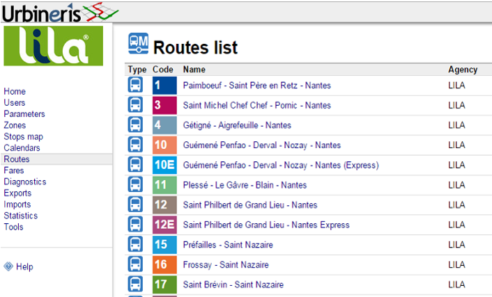
Urbineris is an online transit editor which objective is to produce high quality transit GTFS feed. Urbineris makes it easy to describe a transit network, with many details. Urbineris is the result of several years of experience working with transit agencies.
xxx
Urbiplan-Alert is an online application designed to broadcast transit alerts on multiple channels. The transit agency can inform his users of a temporary service disruption through Google Transit, social networks, SMS, RSS feed, and widgets (embedded in the agency website). Urbiplan-Alert also provides an open API to integrate alerts in a transit application.
xxx
Urbiplan-Static is a software application designed to post-process transit static data in order to improve its quality. Urbiplan-static adresses transit agencies that already produce transit data and want to make sure that the feed produced is of high quality. Urbiplan-Static can be associated to the check & monitoring service in order to automatically monitor and correct the GTFS data produced.
xxx
This application software is designed to process real-time transit data feeds. It allows to perform operations on real-time transit feeds such as transform from a format to another (ex : GTFS-RT), merging several real-time feeds, relate a real-time feed to its static counterpart...
xxx
Google Transit is the transit feature on Google Maps. It allows any user to plan a trip using public transport. Google Transit is based both on the most up-to-date data available provided by the public transport agencies and on the power of Google Maps. Anybody can easily and quickly plan an itinerary, it provides stop, itineraries, schedules and price; for networks all over the world. Mecatran as a transit data builder and provider is able to interface easily with Google Transit, and allows any agency to publish its network on Google Transit.
xxx
The transit data available (static feeds, alerts, real-time information) can be made available through a unified transit API. The transit API comes in 2 forms : a transit 'developer' API, and a widget transit API for website integrators. The transit API can be used by developers who can develop a transit app without worrying about update issues and specific interfaces. They are garanteed to get an up-to-date data. The transit widget interface provides widget with a variety of user functions that can be easily be integrated in a website.
xxx
The widgets are specific transit information services to insert on any website. Widgets are an easy way to insert transit specific functionnality with the guarantee to provide an always up-to-date information to the transit user. The widgets are based on all the transit data available and are always in sync with it. As an example, the "itinerary planner widget" allow users to plan an itinerary on Google maps directly from the website.
xxx
The transport mobile site is a mobile website that make it easy for transit users to travel within your network. It offers all the major functionalities offered by the mobile app. It is also related to a QRCode that transform each of the transit stops into a virtual passenger information digital display. When the users scans the QRCodes, the smartphone displays all the information available at that stop : next bus departure, alerts affecting the stop or the routes, or simply the theoretical information.
xxx
An interactive map to be added to a transit website. It allows users to understand the transit network, such as understand what are the main lines, and stops, what are the geographic coverage of a transit line... It allows access to schedules and other local specific points of interests.

Meet the founders

A transit team at your service


team

Nicolas Taillade

Director

team

Laurent Grégoire

Technical director

References


Our Work

Some example and use-cases of our latest achievements


Latest News

The companie's latest news


French Ministry of multimodal information instructs Mecatran to develop an open-source GTFS library

December

2015

TIDEO is now on Google Transit

The 3 inter-urban lines of Lot et Garonne are on Google Transit

31

August

LILA improves their transit data

Urbineris is used to generate GTFS

15

July

RTM Marseille on Google Transit

One of the biggest french cities on Google Transit

1

June

Contact Us


Drop us a message

Contact Info

Emplacement: Bassins à flots, Bordeaux, France
Email: info@mecatran.com
Website: www.mecatran.com